On Wednesday 19th May, 2021, I drove from home to Exton, via M3, then on Morestead Road, which went off M3 on A272, then A31, then on Morestead Lane, then on Corhampton Lane, then left and took a lane into Exton village & parked on side of road near a house wall. Then I walked along the road from Exton, passing the Shoe Inn, then walked up and crossed the A32, & went up a lane, and walked straight along this lane and came to the Meon Valley Railway Line, that at one time went over the lane I was on, using a bridge, but this has now been demolished, so there are some steps on the right, that go up to the old railway line. I then started walking along this old railway line towards the bridge over the line near Soberton.
I saw a signpost, that said that Wickham was 5 miles away, so that would make a new nice walk. The old railway line was quite wet & mucky in places.
The line came to a place in Droxford, where in World War One, in 1944, Sir Winston Churchill, & General Eisenhower met to discuss an invasion of France. There is a siding there & a plaque.
Then I saw the bridge over the railway that goes to the village of Soberton, where I was going to go up some steps, and onto the lane to Soberton.
The steps were not complete, and the wooden bar across them, was a difficult place to get through & over.
Then I walked up the lane to Soberton village, & used the Wayfarers Walk to go up onto the hills, towards Hambledon. I walked up the lane from the bridge, went to the right, then left, then right, passing a public house, outside which was a footpath signpost.
Then I walked down the lane, coming to a lane which I crossed, with a footpath sign showing me the way forward up the lane ahead.
Then I went up the lane, and came to the path that went to the left, with a signpost indicating the route to the left.
I walked up this lane, and then up the path, next to a field, with a gateway.
As I walked towards the stile that goes onto the downs, I came to a tree that was across the path, and very low.
On reaching the stile, I then walked up the green field at the top of the hill,
On reaching the place where the Wayfarers Walk goes to the right, where there was a waymark sign, as the one below, now there isn’t one at all.
So, I walked on the Wayfarers Walk towards Hambledon, which I have been on twice before, and soon came to Hambledon, where the signs there have improved now, and ended up, walking through the churchyard, then up the lane where I came to the kissing gate that goes to the right on the Wayfarers Walk, just to look at it and the gate that goes up hill.
Then I turned back to the lane that goes uphill, looking for the footpath, that is the Monarch’s Way, which in the book I was following, said it went through someone’s garden. I missed seeing this footpath, and ended up where the lane goes next to the Wayfarers Walk, so I walked back, and ended up walking down a lane towards a farm and house, meeting a footpath, going to the left & right, called Monarch’s Way.
The person I met, who is in the above photo with dogs, told me that the footpath that went to the left, went to the lane that walked up from Hambledon village, so one day I am going to have to search for this place where this path leaves that lane.
I then followed the footpath sign, that showed me the Monarch’s Way route from Hambledon, one of the Monarch’s Way footpath signs, going through a gate, took that way towards Horndean, whilst the other one took me across the fields towards a cattle farm.
The path above was the Monarch’s Way which I went on that was going towards Hambledon PH, whilst the picture below, which shows the Monarch’s Way going over a field towards some woods, confused me at first, because I thought that was the way I was going to walk, but then I realised it was going in the wrong direction, so I took the green path above.
The green path then came to a kissing gate, and went over some fields, and through other kissing gates to reach a cattle farm.
A gate led me onto a mucky track, that took me next to a cattle farm, where I turned left & walked up a track, and then went right, along a track, next to a pond.
I followed the next track, that went uphill, coming to a junction, where I turned right, went along another track, and came to a place where the footpath, went to the left, with a footpath sign on a bank full of nettles.
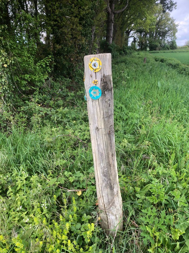
This path was narrow, and came onto a field, then went up a narrow path, coming out onto a farm lane, where I saw a sign on a post saying Monarch's Way, so I knew I was on the right path.
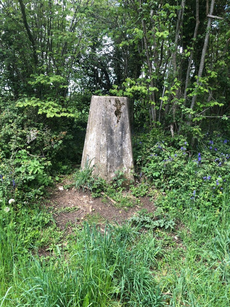
I turned right, and walked along the path next to the farm, then up a track, passing a trig point.
The path I was on then turned right, and went along a track through a forest of fir trees.
The track then came out of the wood, and walking downhill, with a road on the left-hand side, across a field, I saw a stile, with a Monarch’s Way sign on it, showing that the path went across a field to the road below, so I walked down the path, reached a stile before a road, and saw another Monarch’s Way, showing me to the right.
So, I then went along the side of this road, and soon came to Bat & Ball Public house, with a cricket ground opposite the public house.
I then turned left, & walked along the lane, going passed the cricket ground on the left, with a plaque.
Near the entrance to the ground I found a notice board with the name of the cricket club that played on the cricket ground.
A few hundred yards later I came to a footpath sign & Monarch’s Way sign too, showing me that I was going to walk towards Chidden.
A few hundred yards later I came to a footpath sign & Monarch’s Way sign too, showing me that I was going to walk towards Chidden.
It did begin to rain as I crossed this path, but stopped when I reached the lane, I walked up the lane looking for a footpath, which was the second one on the right- hand side, and found it complete with Monarch's Way sign on it.
I walked along this footpath, next to a field, and came where it went through the hedge on the left, and onto the path, going with the hedge on the right- hand side.
I then came to where the path went to the right, complete with signs on a waymark post, so I went right, following the signs towards a place where the path went off next to a field, towards another lane.
The Monarch’s Way then came onto the lane which to the right went to HMS Mercury, and to the left towards Soberton.
I crossed the road, & followed the lane downhill, which was going to the right, and where the slope finished, came to a footpath going to the right, with Monarch’s Way signs on.
So, I then went along this footpath on a field edge, going through a metal gate, and coming out onto another lane, where in front of me was Old Winchester Hill.

I followed the sign, showing me to go to the left, went along the lane for a short way, then followed another sign, down a track, to meet another sign.
I then walked across a field on a footpath in a growing crop, going towards another stile and facing a stiff climb uphill.

I went up the steep hill, and came to another sign, climbed over it and went up and along a footpath through a wood. I stood on the stile and looked downhill the way I had just come from.
The way I had come from the top, so I could see the way King Charles 1 must have gone down on his horse.
The path I went along, from the stile went through a wood, and then came to another stile, that went onto a road, that I walked on going right, towards an entrance to cross over Old Winchester Hill.
By now the battery on my phone was running down, so taking photos got slower. Going through the gate onto Old Winchester Hill, I came to a couple of plaques, and then started walking towards to old fort on the hill, following signs to South Downs Way & Monarch’s Way.
I came to where the South Downs Way went to the left, and the Monarch’s Way straight forwards, so at first, I walked on the Old Fort, then walked back to the South Downs Way
The South Downs Way went through a gate, then turned left, & went down a sloped path.
At the bottom of the sloped path, I saw a sign showing the South Downs Way, and then I walked along this path which was going on a grassy path.
Then I went down a slope, and followed this South Downs Way, meeting the Monarch’s Way coming from the right, and went down both paths, then down the South Downs Way, and met the Meon Valley Railway Line, crossed over it, and took the footpath, to cross over the River Meon, then over the A32, and along a lane to find the car parked in Exton, then drove back home again.
I checked my Garmin Watch & saw I had just walked 16.90 miles.