On Wednesday 9 September, 2020, at 0900 I caught the train from Basingstoke to Eastleigh, having already walked 2.46 miles from home, then at Eastleigh, walked to the bus station at stop A and at 0950, caught bus X17 to Droxford arriving about 1030.
Looking at the map I could see the route along the Meon Valley to Soberton, then down the main street, and up a lane, then across a hill, down a track, then left along another path, then left when another path went right.
So, then I walked towards the church, then saw another sign pointing to the right and walked along a graveyard on some stone slabs.
So, I walked left along this lane, crossing a railway bridge, and looking down saw the track of the old railway line which I have cycled along.
So, I crossed West Street, and walked up the lane which went up a hill
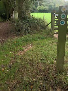
Then I turned left along a track, and crossed the River Meon on a footbridge. Then I had to turn right, and go through a wooden kissing gate.
Then I walked along a grassy path, & through a field with cattle in it.
Then from this field across the other side at an angle.
Then through some woodland, then along a path next to an old railway line.
Then eventually at the end of the field path, I came to a lane that went over the Meon on a bridge, and a sign post pointed the way to the left.
I walked up the lane, went right at the top, then near a public house saw this sign.
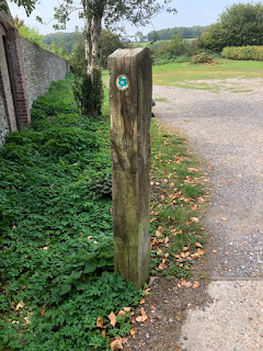
So, I went down a lane, and at the bottom, where I met another lane which on the map is called West Street. I saw signpost pointing the way uphill, up a lane opposite from where I was standing.
So going up the driveway then I saw a kissing gate and a footpath sign up a steep climb.
So, as I walked along the edge of a field, I saw a sign pointing to the left.
Anyway, the sign pointed me to the left and then I entered a path that runs in woods between two fields. The paths were Wayfarers Walk and Allan King Way and a third walk called Soberton & Newtown Millennium Walk.
Soon I came to a place where one path called Kings Way went off to the right, whilst Wayfarers Walk went to the left, next to a wood, with a field close by, and the path between two of them.This was the path next to a wood, with a field close by.
So, I had been walking next to Shere Copse, and the track to the left went alongside it, whereas I went straight on towards a lane called East Hoe Road.
The path went down the side of the hill and eventually ended up on a lane.
There was a metal footpath sign, situated at the side of the road, pointing up the hill, that I had just come down. So, it was there to assist persons doing the walk from Hambledon to Droxford.
I saw the footpath sign, and looking at the map, saw that the Wayfarers Walk, went along a footpath parallel with a street in the village of Hambledon.
Unfortunately, as I crossed the lane & walked towards the footpath, a few people came, so I didn’t take a photo of the footpath sign, but I am sure that there was no Wayfarers Footpath sign at all.
When I went on the walk the second time, I saw a wooden sign showing the route ahead, but no Wayfarers Walk sign on.
Speaking to a member of the public, he showed me a wooden direction sign which was covered with foliage from a hedge that is to the right of the footpath.When you look at the OS map, there are 2 dotted green lines, so no knowing which path to take.
So, as before I wasn’t sure if I was on the right path-I walked along this footpath, which looked like this:-
Then I came to the wall around the church, and turned right along a footpath, but again no Wayfarers Walk signs there at all. Walking the second time, having read the instructions, told me to turn left, walk towards the church entrance, & walk through the graveyard to exit the church.
The path came out on to a street and ended up on a main street in the village.
Now having read an article about doing this walk, at this point, I should have turned left, then walked along path to the church, then gone right, through the graveyard to emerge onto a lane and walk down to the main street. I think when I did this walk last Wednesday, I saw the lane called Church Lane, which meets the main street, then goes up
Looking at the OS map, the Wayfarers Walk looked like it went up a lane from the village, almost opposite Church Lane.
I saw this lane and it’s name on a wall, called Speltham Hill, but no Wayfarers Walk signs at all.
So, I decided to walk up the lane, and then much to my pleasure I saw a road sign saying the lane was unsuitable for wide or long vehicles and on the post was a Wayfarers Walk sign.
The road was quite steep, with a few parked vehicles next to houses, and then as the lane went left, there was a gateway, with Wayfarers Walks sign on.
I went through the gate, then on the left saw another gate, with a Wayfarers Walk sign on it,which went up a very steep hill, where there was a bench at the top,
Then I went between some trees and over a stile and then across a field and came out on a laneThen I walked down a field path, turned left, then walked along the field edge, then turned right The map below shows the way-the path was going with Rushmere Lane on the left- hand side.
Eventually, the path moves towards Rushmere Lane, where I saw a sign post, showing the Wayfarers Waymark pointing down the lane, which I walked on for a short way.
Then saw a footpath on the left-hand side, with a sign in the hedge & trees all covered up.
When I walked the second time, I saw that the footpath sign had been uncovered for walkers going from Hambledon to Denmead, but not in the other direction, as it was covered with foliage. So, I used my secateurs to remove some of the foliage, so it now makes the bank of the sign more visible. On the other side of the road, in the hedge is a gap suitable to put another post and waymark sign pointing to the right and left.
The next part of the route is on this map.
The path then came out onto a lane and met another one, and there was a kissing gate and footpath sign but no Wayfarers Walks Way marks at all.I think I saw a waymark sign on the signpost hidden amongst some vegetation, So, the next time I went, I took my secateurs with me and cut the foliage away from the gate posts and near the fingerpost, and found the waymark signs, for walkers walking from Hambledon to Denmead and in the other direction.
So, then I followed the footpath along a field edge, with a field on the right-hand side. Quite soon the path came to a junction with a path going off to the right, towards High Wood, but the OS map said the Wayfarers Walk was straight on, but again there were no waymark signs on posts at all.
So, then I went along the footpath going towards the village of Denmead.
Looking at the map, I could see that the path went past a cemetery, then turned right along a path, and then came out onto a road, then walked on the estate road to meet the B2150.
So, looking at the OS map again, I could see that the Wayfarers Walk, went from the B2150, through a housing estate and then onto another road which must be a minor road because it doesn’t have a name on it.
which goes off to the right, indicating a golf course down the lane, but again no Wayfarers Walk signs on a 30 mph post at all.
So, I walked down this lane which had a pedestrian line on, so walking along the right- hand side of the lane, then soon I came to another waymark sign and news about a golf course.
So, on the map, now I was walking towards Glenfield Farm, and sure enough, the footpath, went next to a farm building with trees on the right.
Then I crossed the golf course, then over a field towards some trees, where there was a house and garden on the right-hand side. The path then came to a lane, with a sign indicating the way to the right along a lane. The lane met another lane, with a signpost indicating the routes for the traffic, but no footpath signs on at all.
Then the track came out onto a lane called Purbrook Heath Road, and a sign pointed the way to the left.
Looking at the OS Map, I could see the way along this road.
The lane goes for about a mile, then passes a lane to the right, which isn’t the route at all. The lane then meets the road coming from Denmead, and on the map is a green dotted line, going through some woods, that then straightens up and goes south on Purbrook Heath.
According to the instructions, they say “In Purbrook Heath, turn right down a lane”, but there where this land leaves the road, there is no footpath sign at all, which is most unusual”
I found a track going off to the right, but didn’t find the path through the woods as the OS map says, so I walked to the end of the track, where there were some houses near, and came to a kissing gate with a Wayfarers Walk waymark on.
I followed this path which went south, crossing a footbridge and going uphill, then going left, then right, along the back of some houses.
I went left along this road called the B2177, then crossed it and as I saw some people walking along it and I asked them if I could walk down the A3 to Cosham Railway Station.
I was now going to follow my next map, which would show me my direction from this B2177, along the A3, and to Cosham Railway Station, rather than continuing my route along the Wayfarers Way towards Exmouth.
Eventually, I came to the railway station and much to my joy checked the time and found I had only a few minutes to wait for the train, so I took a photograph of the station. So, then the train came and I got on it and went back to Basingstoke, then caught number 7 bus back home.


No comments:
Post a Comment