Walking the Wayfarers Walk for the first time in my walking history in 2020.
On 19th November, 2018, so only a few months since my wife and I had moved to Basingstoke, I did a circular walk from Kintbury Station to Combe Gibbet & Walbury Hill, and then walked back to Kintbury. Doing this walk, having walked down from Combe Gibbet, I saw a wooden post with the name on it called Wayfarers Walk.
Okay it must have been getting a bit dull when I took this photo, as the the name on it isn't very clear. So, looking at my OS map number 158 Newbury & Hungerford Explorer I saw on it a footpath called the Wayfarers Walk. Then looking at my OS map of Basingstoke, called Basingstoke, Alton & Whitchurch, OS Explorer 144, I saw the Wayfarers Walk going over the A34, and ending up near the M3 near Basingstoke. Going online, I found out all about it on this website:
https://www.hants.gov.uk/thingstodo/countryside/walking/wayfarerswalk
On July 16, 2020, I took the bus from Basingstoke to Kingsclere, then walked up to the top of White Hill, then along the gallops to Watership Down. Then I walked back to Kingsclere and on the top of White Hill, as I walked from a car park there onto a footpath I saw a signpost saying “Wayfarers Walk to Emsworth” So I looked at my OS map number Explorer 144 and saw the Wayfarers Walk went from near East Woodhay to cross the A34, then from there up past Ladle Hill, then over Watership Down, then to White Hill, crossing the B3051, then it went to North Oakley, then to Deane, then under the railway line between Basingstoke & Winchester, then to near Oakley, then to Dummer, crossing the M3, and then the Wayfarers walk on this map went towards Preston Candover.
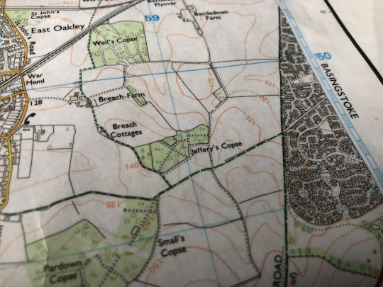
So, looking at my OS maps of the Basingstoke area, I couldn’t work out how I was going to be able to walk on to this footpath from Basingstoke itself. Looking at my OS map this was what I saw when the Wayfarers Walk got near Basingstoke.

Walking the Wayfarers
Way from Kingsclere to Basingstoke
On Saturday 1st August, 2020, I decided to take the bus to
Kingsclere, then walk up Anchor Road, then up the football field, then past the
gallops,
and then up a side hill, then right along the
top of the hill, until I found a kissing gate, and could see the TV
transmission mast very clearly.
and went up the footpath till I reached the top of the hill; I did look down from the top of the hill towards Kingsclere;
-
then turned left along a footpath
towards Freemantle Park Farm as shown on the map. The footpath now I was
walking on was indeed a lane, which went up a hill and joined another lane
called Meadham Lane.
I walked along Meadham Lane and soon reached the Wayfarers Way coming in from the right hand side, crossing the lane and going along a farm track towards Walkeridge Farm.
As seen on the map below, the footpath went to North Oakley, down a path, then left along a track towards the village.
The path the follows a footpath through a farm yard, then along a path, and out onto a track, where it turns left and goes to Freemantle Farm, turns right up a track to the top of the hill, which has signs on it,
I was now following the Wayfarers Walk on my map as it is shown below:
The signs above are on this area of the map below:
They are near the bottom thick green blob-I had already walked past Freemantle Farm and up a hill, then turned left, then turned right and saw those signs above.
Then I walked down the hill and through a wood which has footpaths signs on the trees.
The wood I was walking through is called Frith Wood, and there is a gap between Frith & Patchbourne Wood before it meets White Lane-and this is the gap.
The path goes next to Patchbourne Wood, then Great Deane Wood , and then crosses a wheat field, goes along a track and goes across another field towards a small lane & Deane Down Farm.
The path then goes right along the lane, which has the railway line to Salisbury from Basingstoke next to it. We then leave the lane and go over the railway line on a footbridge.
The path now goes across a field and downhill to Deane village, turns right along a lane, then left to the road between Basingstoke & Whitchurch, which I crossed, then went along a lane, then turned left up another track and under the railway line between Basingstoke & Winchester. I sat at the top of the track overlooking the railway line and could see the transmission mast at the top of the hill at Kingsclere
The path goes next to another wood and comes to a lane that goes between Dummer & Oakley. I walked over this lane and along another track, and seeing the Wayfarer’s Way going off to the right, as shown by waymarks,
I walked over a field, and crossed a lane, called Pardown, then walked along a bridleway near Pardown Copse to come out onto a Roman Road near Kempshott.
In the future I will follow the Wayfarers Walk, because I know now where it goes to and how I can get back from its route to Basingstoke. On this occasion I walked along the Roman Road & cycle path and ended up in Winklebury, and caught the bus back to the railway station bus stop so I could get home from there ok.
So that's the end of this story, soon I will add another story of walking the Wayfarers Walk.


No comments:
Post a Comment